Understanding our Fire Danger Signs
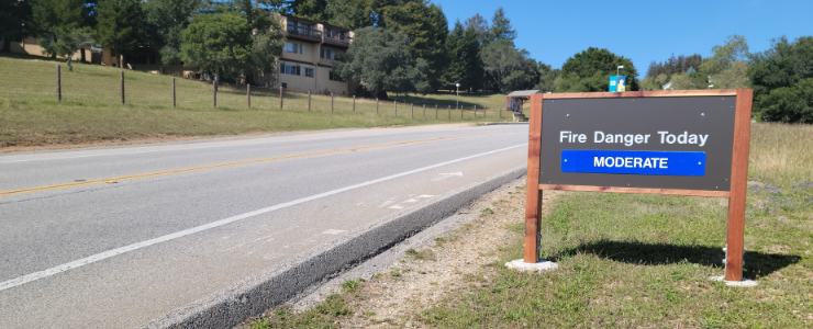
The Fire Danger sign positioned at the west campus entrance.
Fire Danger is a persistent and ever-present part of our California lives. Since UC Santa Cruz is situated amidst both forest and grasslands, taking stock of our current environment helps us both understand and mitigate the hazards that our community faces.
Fire Danger is not a static label, it is a measurement of risk given a variety of conditions. In this article we will explain what the risk of fire danger means, how risk is determined, and why we present such foreboding signs at the entrances to our campus.
Campus Fire Danger Ratings
Put simply, there are five possible ratings for fire danger on our campus. These are:
- Low (Green)
- Moderate (Blue)
- High (Yellow)
- Very High (Orange)
- Extreme (Red)
These ratings are designed to illustrate the probability of fire ignition and spread on our campus. We consider both ignition and spread because these factors determine the danger a fire poses to our community. A fire that does not ignite... isn't a fire. A fire that does not spread will be subdued as soon as its fuel is depleted.
As a result, we can consider the classifications on a sliding scale where Low danger indicates a low probability of fire ignition and spread. Conversely, Extreme fire danger means a remarkably high probability of fire ignition and spread.
With this in mind, we can now provide definitions for each classification:
| Fire Danger Rating | Definition |
| Low (Green) | Fires are unlikely to start and the environment will not be conducive to wildfire spread. |
| Moderate (Blue) | Fires are plausible and pose risk. Fires can spread at a moderate pace but control should not be difficult. |
| High (Yellow) | Fires can start easily from most causes. Fires may become serious and thier control difficult unless attacked while small. |
| Very High (Orange) | Fires are likely. Fires can spread at a fast pace with environmental conditions that will make control difficult. |
| Extreme (Red) | Fires can start and spread rapidly. Environmental conditions are conducive to erratic behavior that make control difficult. |
Special Weather Alerts
The UC Santa Cruz Fire Danger signs include a special feature where special weather alerts are displayed in addition to the 'Fire Danger Today' status. These Special Weather Alerts include the following:
- Red Flag Warning: Issued for weather events that may result in extreme fire behavior that will occur within 24 hours.
- High Surf Advisory: Issued when breaking wave action poses a threat to life and property within the surf zone.
- Public Safety Power Shutoff: Issued when the local power utility, in our case Pacific Gas and Electric, expects to turn off power within the next 24 hours to mitigate wildfire starts.
- High Wind Advisory: Issued when a hazardous high wind event is expected or occurring
How Fire Danger is Determined
The Fire Danger Rating that is used for our campus is determined through the Wildland Fire Assessment System (WFAS) and the Climate Ecosystem Fire Applications (CEFA). Weather stations across the United States report on environmental conditions. These reports, combined with data from the U.S. Forest Service (USFS) creates an image of fire danger across United States that is referenced by our Designated Campus Fire Marshal (DCFM).
There are many conditions that are used to generate this map, among them are:
- Relative Humidity - The ratio of the amount of moisture in the air relative to the amount of moisture needed to saturate the air. (Lower RH indicates greater fire behavior).
- Fuel Moisture - The approximate moisture content of live and dead vegeation that can fuel a fire. (The drier it is, the easier it is to burn).
- Fire Weather - A combination of wind speeds, rain totals, temperature, relative humidity, and dew point that help determine if weather conditions are conducive to fire spread.
- Greenness - A visual representation of live fuel moisture by assessing how 'green' a geographic area is.
- Keetch-Byram Drought Index (KBDI) - A measurement of the effects of seasonal drought on fire potential, where higher values occur where live plants die and become fuel and litter levels become more susceptible to fire.
- Haines Index - Also known as the Lower Atmosphere Stability Index and is computed using the dew point at an atmosphere level and the difference in temperature between two atmosphere levels. Has been shown to correlate with large fire growth.
- Lightning Ignition Efficiency - A measurement of how likely it is for a lightning strike in a certain area to actually ignite a fire.
- Lightning Activity Levels - A measurement of how often lightning is striking a specific area.
Why the Signs?
The fire danger signs that you see at the entrances to campus are designed to inform our campus community. It is easy for us to ignore fire danger when fires seem both far away and rarely impact our specific campus. When we ignore that danger, we may take actions assuming it simply does not exist.
Examples of these actions can run the gamut between simply not knowing what to do in case of a fire to actively igniting illegal campfires or barbeques.
By having these signs at the front of our campus, they serve as both a reminder and an update to our community. In doing so, they accomplish two primary tasks:
- Remind our community that fire danger is always present on our campus.
- Inform our community regarding the degree of danger the current environmental conditions pose.
The first step of preparedness and readiness is simply knowing what is possible. Put simply, fires are possible on our campus. Informing our community of that possibility and providing resources to help our community prepare for them, prevent them, and respond to them are core responsibilities of the Designated Campus Fire Marshal.
